|
List Your Business Now! Its Free and Easy. |
|
|
GUIDE TO SOUTH AFRICA
A Beautiful Country The People of South Africa Useful and Interesting Information Current Affairs SHARE THIS PAGE
|
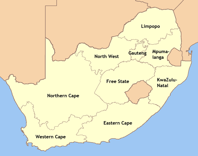
Provinces of South AfricaSouth Africa is divided into nine provinces: Eastern Cape, Free State, Gauteng, KwaZulu-Natal, Limpopo, Mpumalanga, North West, Northern Cape and Western Cape. Province Population StatisticsIn terms of population size, KwaZulu-Natal is the most populous province, with more than 10 million people. The province of Gauteng follows closely, with more than 9.6 million residents. The Northern Cape has the least people, with just over 1.1 million. The Northern Cape is also the largest province by far in terms of land area, occupying 361 830 kmē. Due to the relatively small number of people that live in the province, it has an average population density of just of 3 people per square kilometer. On the other extreme, the province of Gauteng only occupies an area of 17 010 kmē, making it a very densely populated province with more than 569 people per square kilometer on average. In most cases, the largest city in the province is also the capital of the province, with the exception of Port Elizabeth in the Eastern Cape (where Bhisho is the capital), Durban in KwaZulu-Natal (where Pietermaritzburg is the capital) and Rustenburg in the North West (where Mafikeng is the capital).
Map of the Provinces of South AfricaFour provinces, the Northern Cape, Western Cape, Eastern Cape and KwaZulu-Natal, border oceans (the Atlantic Ocean to the west and the Indian Ocean to the east). Most provinces border one or more of South Africa's neighbouring countries - Nambia (Northern Cape), Botswana (Northern Cape, North West and Limpopo), Zimbabwe (Limpopo), Mozambique (Limpopo and Mozambique), Swaziland (Mpumalanga and KwaZulu-Natal) and Lesotho (Free State, KwaZulu-Natal and Eastern Cape). Gauteng is the only province that do not share a border with a neighbouring country or have a coast line.
History of the Provinces of South AfricaWith the establishment of the Union of South Africa in 1910, South Africa were divided into four provinces: Cape Province (with capital Cape Town), Natal (capital Pietermaritzburg), Orange Free State (capital Bloemfontein) and Transvaal (capital Pretoria). The Cape Province and Natal were former British colonies (Cape Colony and Natal Colony) and the Orange Free State and Transvaal were former Boer republics (Orange Free State and Transvaal Republic). There were also a number of independent homelands or bantustans within the borders of South Africa, referred to as the TBVC states. These were Transkei (declared independent in 1976, capital Mthatha), Bophuthatswana (declared independent in 1977, capital Mmabatho), Venda (declared independent in 1979, capital Thohoyandou) and Ciskei (declared independent in 1981, capital Bhisho). In addition, there were a number of non-independent homelands: Gazankulu, KaNgwane, KwaNdebele, KwaZulu, Lebowa and QwaQwa. With the changing political climate in South Africa in 1994, it was decided to reunite the four former provinces and the various homelands. These changes came into effect on 27 April 1994, the day of the first general election in South Africa. South Africa was then divided into the nine provinces that exist today: Eastern Cape (parts of Cape Province, Transkei, Ciskei), Free State (Orange Free State, QwaQwa), Gauteng (parts of Transvaal), KwaZulu-Natal (Natal, KwaZulu), Limpopo (parts of Transvaal, Venda, Lebowa, Gazankulu), Mpumalanga (parts of Transvaal, KwaNdebele, KaNgwane, Bophuthatswana, Lebowa), Northern Cape (parts of Cape Province), North West (parts of Transvaal, parts of Cape Province, Bophuthatswana) and Northern Cape (parts of Cape Province). |
Copyright © 2003-2009 BizPages CC. All rights reserved.
